

Research and development on Web-based 3D geographic information model management system
-
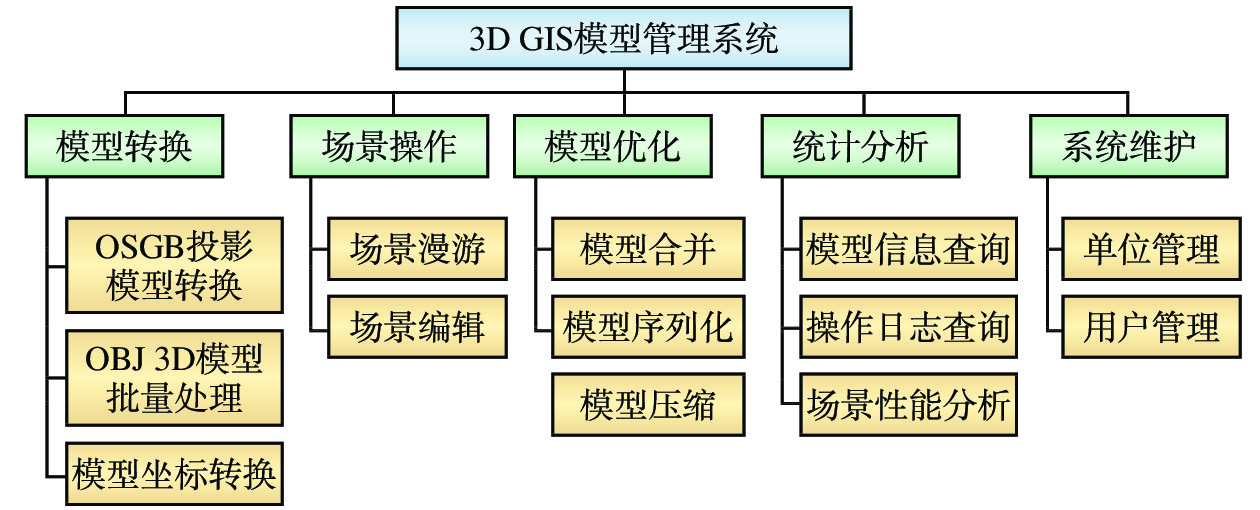
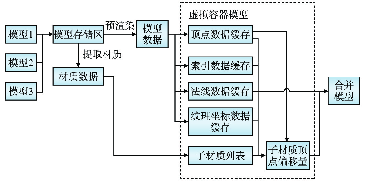
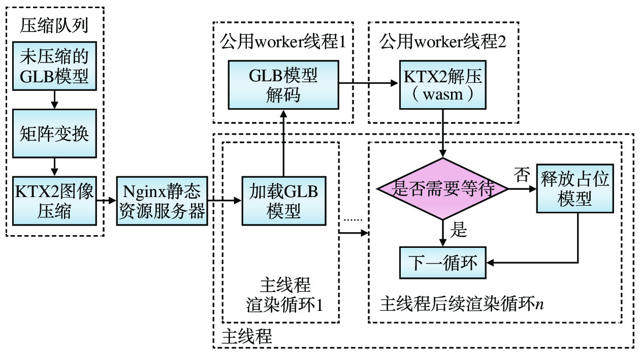
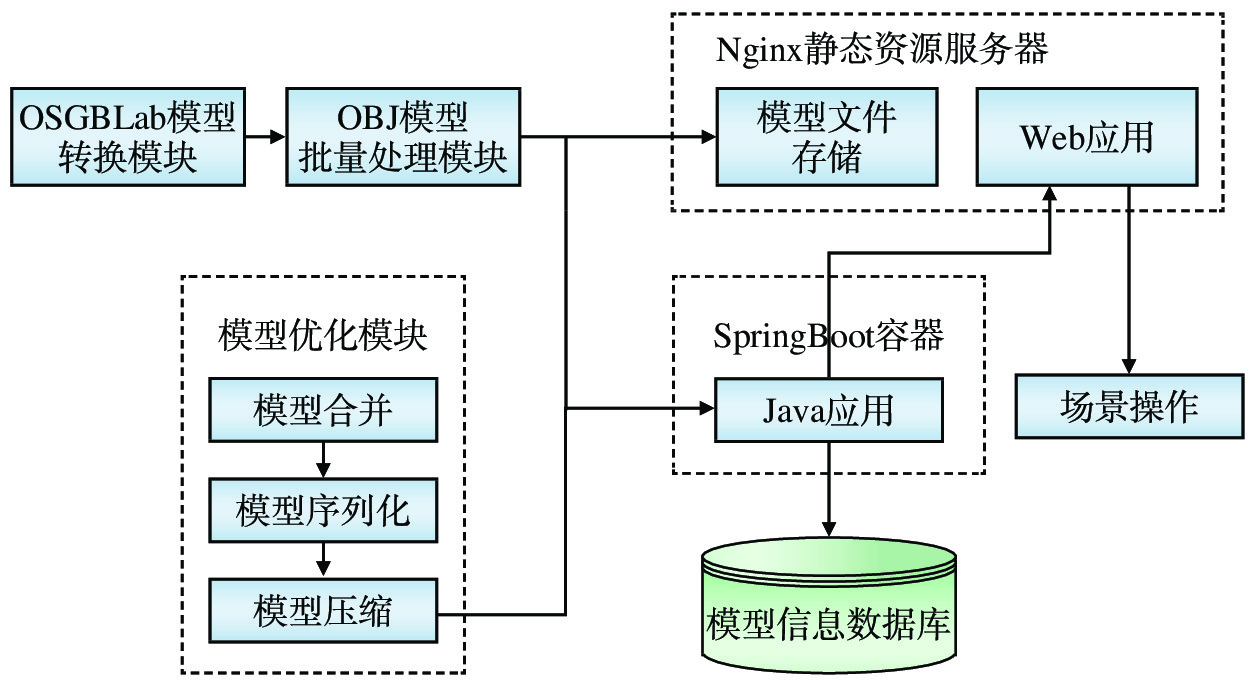
摘要: 数字孪生技术在我国各行业的应用正在加速推进,三维地理信息(简称:3D GIS)模型是数字孪生技术不可或缺的基础数据模型,开发具有自主知识产权的3D GIS模型管理平台的必要性不言而喻。参考开源地理信息框架Cesium,使用Java和JavaScript语言、开源代码及国产模型转换工具,开发基于Web的3D GIS模型管理系统,实现了LOD计算、模型合并与序列化、渲染优化、模型压缩与解压、场景漫游自定义控制等关键技术,能够将由无人机航拍的倾斜摄影像片转换为在Web浏览器中浏览的3D GIS模型,支持大容量3D GIS模型数据管理,方便用户高效完成场景编辑和模型渲染,提供安全、简便的数据共享接口,能够与其它信息系统无缝集成,为各类业务应用开发提供所需的数字孪生资源,方便各类业务应用以空间信息为载体整合相关数据,为业务提升赋能。Abstract: Today, the application of digital twinning technology in industries is accelerating. Since 3D geographic information (3D GIS) model is one of the indispensable basic data models of digital twinning technology, the necessity of developing 3D GIS model management platform with independent intellectual property rights is self-evident. By referring to the open source geographic information framework Cesium and using Java and JavaScript languages, open source code and domestic model conversion tools, the 3D GIS model management system based on Web is developed, and key technologies such as LOD calculation, model merging and serialization, rendering optimization, model compression and decompression, and customized control of scene roaming are realized. This system can convert oblique photograph taken by unmanned aerial vehicle into 3D GIS models browsed via Web browser, support large-volume 3D GIS model data management, facilitate users to efficiently complete scene editing and model rendering, provide safe and simple data sharing interface to enable seamless integration with other information systems. Besides, it can provide digital twin resources required for the development of various business applications and facilitate the integration of relevant data to empower business improvement by using spatial models as the carrier of various business applications.
-
-
[1] 童杨津,丁进选,赵文峰,等. 倾斜摄影在城市道路竣工测量中的应用分析 [J]. 科技创新与应用,2022,12(31):39-42. [2] 陶 飞,刘蔚然,刘检华,等. 数字孪生及其应用探索 [J]. 计算机集成制造系统,2018,24(1):1-18. [3] 郑之光. 基于Cesium的多源异构三维数据地理配准研究 [J]. 中阿科技论坛(中英文),2023(4):121-125. [4] 高亚伟. 基于开源引擎的三维场景基础平台搭建方法及实现 [J]. 测绘标准化,2023,39(1):22-26. [5] 许叙源. 基于Cesium的水陆融合三维场景构建研究 [J]. 广东水利水电,2023(2):80-83. [6] 刘 娇. 一种基于Cesium的公路数字孪生平 [J]. 中国科技信息,2023(4):90-91. [7] 李婷娜,田冬迪,董明泽. 基于Cesium实景三维共享服务的研究 [J]. 智能建筑与智慧城市,2022(6):46-48. [8] 丁田妹,徐发达. 三维模型中多层次细节LOD技术研究 [J]. 电子制作,2021(18):35-37. [9] 代欣位,郭甲腾,刘善军,等. 基于动态四叉树索引的三维地质模型组合剖切算法 [J]. 地理与地理信息科学,2020,36(4):8-13. [10] Dave Shreiner, Graham Sellers, John Kessenich. OpenGL编程指南(原书第8版)[M]. 北京: 机械工业出版社, 2016: 7-10. [11] khronos国际标准化组织. GLTF文件结构参考文档[EB/OL].https://registry.khronos.org/glTF/specs/2.0/glTF-2.0.pdf. [12] Scott McCarty. Why the world needs Wasm [J]. InfoWorld.com, 2022(9).
-
期刊类型引用(5)
1. 王焕松,张荣娜,于胜利,郭祥,娄燕芳. 基于多源影音数据融合的铁路工程调度指挥平台关键技术研究及应用——以广州白云站工程为例. 铁道标准设计. 2024(05): 153-159 .  百度学术
百度学术
2. 周委. 铁路工程管理平台工序报验系统应用. 建设监理. 2023(03): 60-64 . 百度学术
3. 高扬,朱宇,齐彦昆,王雅群,梁家健. 信息技术在铁路安全监督管理中的应用. 中国铁路. 2023(09): 27-33 . 百度学术
4. 焦雄风,马龙,金卫峰,陈铮,张献州. 运营高铁重点监测地段云评估系统设计与实现. 铁道勘察. 2021(04): 43-47 . 百度学术
5. 马海龙,赵永辉,陈宝光,曹庭清. 公路工程管理信息化与云平台的研究及应用. 广东交通职业技术学院学报. 2020(04): 6-9 . 百度学术
其他类型引用(1)
 下载:
下载:

图(7)
计量
- 文章访问数: 146
- HTML全文浏览量: 89
- PDF下载量: 33
- 被引次数: 6
