

Railway network capability utilization analysis system based on GIS technology
-
摘要:
为满足铁路网区间运输能力可视化决策的需求,以及铁路枢纽紧张区段日常分析要求,基于地理信息系统(GIS,Geographic Information System)、大数据技术,设计了集铁路运行线、经营、客票、货票、计划、统计等多源运输数据信息为一体的铁路网能力利用分析系统。提出了面向高速铁路、普速铁路的实际通过能力计算方法,以及融合客/货运密度、客座利用率的计算方法;构建了标准统一的时空信息关联模型,将多源数据信息与GIS数据进行融合,实现了铁路网运输能力的可视化表达、多维统计、智能检索、一省一图、车站到发量分析等功能。试点应用表明,该系统能够显著提升面向铁路网的分析能力,减少数据维护工作量,对改善铁路运输能力提供信息化支撑。
Abstract:To meet the demand for visual decision-making of railway network interval transportation capacity and the daily analysis requirements of busy sections of railway hubs, this paper designed a railway network capacity utilization analysis system based on Geographic Information System (GIS) and big data technology, which integrated multiple sources of transportation data information such as railway operation lines, operation and management, passenger tickets, freight tickets, planning, and statistics. The paper proposed a calculation method for the actual throughput capacity of high-speed and conventional railways, as well as a calculation method that integrated passenger/freight transport density and utilization ratio of the passenger seating, constructed a standardized and unified spatiotemporal information correlation model, integrated multi-source data information with GIS data, and implemented functions such as visual expression, multidimensional statistics, intelligent retrieval, one province one map, and station arrival and departure volume analysis of railway network transportation capacity. The pilot application shows that the system can significantly enhance the analysis capability for railway networks, reduce data maintenance workload, and provide information support for improving railway transportation capacity.
-
随着社会经济的快速发展,我国东部主要铁路干线运输能力逐渐饱和,亟需分析不同线路、不同区段站间的运输能力及各运输参数指标情况,进而确定线路的运输能力,掌握各铁路区间能力的薄弱环节[1-2]。根据《铁路区间通过能力计算办法》(铁运字〔1984〕664号)[3],计算铁路通过能力利用率的主要指标源于平行运行图,但平行运行图无法很好地反映铁路线路的实际运输能力,因此还须计算分析铁路实际运输能力利用率。计算铁路实际运输能力利用率,依赖于列车区间开行对数、运行时分、区间里程、续行间隔、不同等级列车扣除系数等重要参数指标。通常,这些指标需要车机工电辆等单位借助大量终端设备来获取,不仅耗费大量人力和物力,且计算结果存在一定主观性,会对铁路线路实际运输能力利用率的计算产生误差。此外,铁路网区间线路运输能力计算结果较为单一,表达方式也缺乏直观性、实时性,进一步限制了中国国家铁路集团有限公司(简称:国铁集团)对铁路网区间线路、枢纽地区实际运输能力的智能化分析和决策[4-6]。
本文利用地理信息系统(GIS,Geographic Information System)、大数据技术[7],融合铁路实际运行的列车开行对数、客票数据、货票数据、客运发送量、货运发送量、合资公司信息、列出时刻表、列出编组、动车组车载信息无线传输系统(WTDS,Wireless Transmission Device System)等多源数据指标,提供基于列车运行图的开行对数、客货密度、客座利用率等运输能力计算方法,并对其线路及枢纽开展运输能力计算。此外,构建定制化的GIS空间数据,以唯一编码字段为纽带进行融合关联,形成面向铁路网能力分析的数据融合方法,设计研发了铁路网能力利用分析系统,并在国铁集团及部分铁路局集团公司开展了试点应用,能够较好地实现铁路网实际能力利用率及车站客货运到发量的可视化表达和空间分析决策。
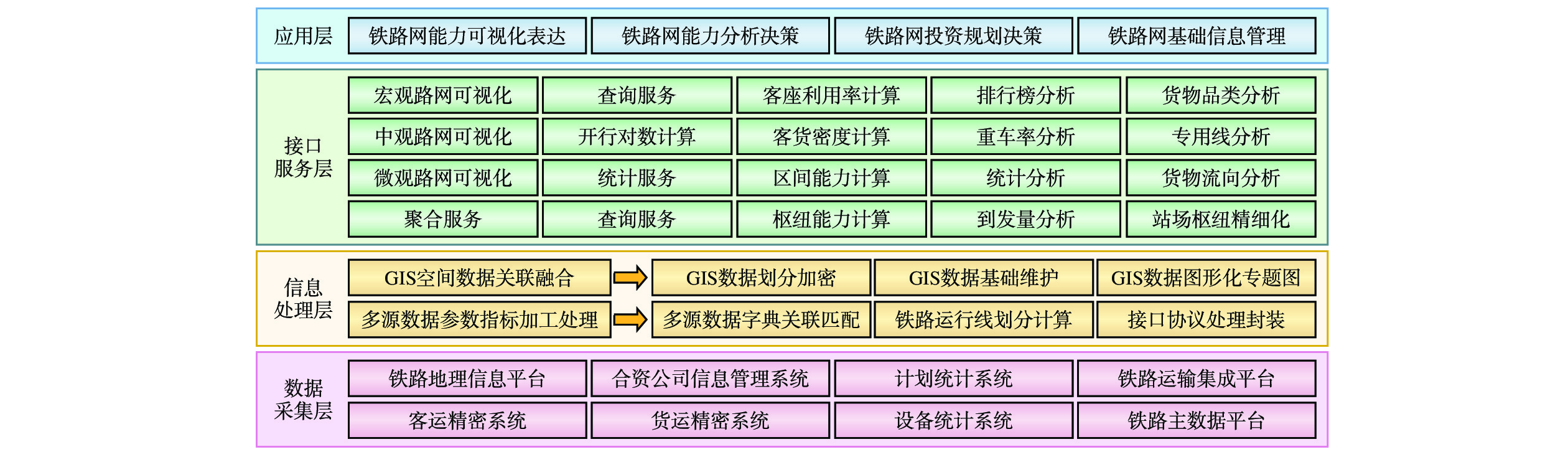
1 系统架构
铁路网能力利用分析系统由数据采集层、信息处理层、接口服务层和应用层组成,其架构如图1所示。
1.1 数据采集层
该层主要负责采集铁路网能力利用分析系统运用时所涉及的多源数据信息,信息主要来源于基础平台、运输、调度等相关统建系统。通过建立固定的时间频率,获取相关系统的数据信息。
1.2 信息处理层
该层主要对获取的数据进行加工处理。对于 GIS 数据,会建立固定的区段编码,开展基础信息制作与专题图制作等工作;对于铁路运行线等业务数据,主要进行数据质量的评估、针对不同时间维度的数据处理分析以及数据的分析计算等。
1.3 接口服务层
该层通过对铁路网能力利用分析系统进行接口封装,为该系统运用的多观地图可视化、空间及业务基础信息查询、统计分析、区间及枢纽能力计算、分析决策及数据管理等业务应用,提供基础的接口信息。
1.4 应用层
通过PC端及移动端提供铁路网能力可视化表达、能力分析决策、投资规划分析、资金清算及数据管理等应用功能。
2 系统功能
2.1 铁路网能力可视化
基于定制化铁路网区间地理信息数据,融合列车开行对数、能力利用率等数据,依据区间的开行对数情况采用不同的阈值,对能力进行动态渲染,目前共划分能力紧张、较紧张、普通、疏松这4类,进而反映铁路网整体的基本情况。
2.2 铁路网能力排行
对铁路网的高速铁路依据列车实际开行对数进行排序,并关联每一条线路的区段、站间信息,同时依据地图不同比例尺下的缩放级别,动态关联排行榜的线路或区段。
2.3 多源数据信息统计
基于历年铁路网区间开行对数、客/货运密度、客座利用率、车站到发量等多源基础数据信息,按年度、月度、节假日及任意时间范围对其进行多源数据的统计和分析,并能自动识别出最大通过能力的时间和铁路。
2.4 空间数据智能检索
对铁路基础信息及运行线等按线路名称及属性信息进行查询、检索及定位,同时,依据关键信息实现图数联动,在地图上进行定位标记及数据可视化展示。
2.5 车站到发量分析
通过接入客货运精密系统、设备统计系统等,获取车站到发量、车站发送量、货物品类等多源数据信息,进而依据 GIS 地图实现车站品类发送量、到达量的展示。此外,利用既有的数据资源,导入车站货运、客运发送量、收入及清算数据,实时显示车站货收率、客收率、货运清算盈余率等指标。
2.6 一省一图
实现对全国各省份、直辖市、自治区等铁路网里程、区域能力的在线动态实时统计,通过任意选择省(区、市)的线路及总里程长度,可完成对能力数据及图片的在线导出和打印。
3 关键技术
3.1 基于列车运行图的最大通过能力计算
3.1.1 面向铁路区间通过能力的计算
列车运行图是用以表示列车在铁路区间运行及在车站到发或通过时刻的技术文件,是组织列车运行的基础[8-9]。
(1)实际运行图数据串线
本文所使用的实际列车运行图数据由铁路调度系统统一提供,主要分为调度记录数据和明细记录, 一条调度数据对应多条明细记录。为方便计算站间车次开行对数,以调度记录数据为基准,根据TRAIN_ID关联查询明细记录表,运行图数据经过串线后转储到中间运行图数据表。
(2)实际运行图数据统计划分
运行图数据按照 24 点划分的方式,依据发车节点的发车时间,将数据每日进行划分,并以日为单位进行处理,以此规避计算车次时开行对数车次重复的问题。
(3)实际运行图数据标记
利用运行图数据计算车次开行对数,须满足2个前提:按 24点划分运行图数据,以及标记车次类型和站间线路,进而将开行对数细化到车次类别和线路。实际中存在共线、共站区间,即多条线路共用轨道或车站。标记时,依据相邻非共线、共站区间的车次来区分并标记线路编号。
(4)普速铁路能力利用率计算方法
普速铁路网实际能力利用率参数指标说明如表1所示。
表 1 普速铁路网实际能力利用率指标说明参数指标 指标说明 各区间追踪运行时分 将货物列车之间追踪运行时间与运行图进行比较,验证运行图参数的合理性,并依据不同列车间追踪运行时分,确定追踪换算系数。 各区间运行时分 比较不同列车区间占用时间,用于计算各等级车次换算系数。 各区间起停附加时分 开行较高速度等级列车,对普通货物列车的影响次数,及起停附加时分,计算不同等级列车对能力的附加影响系数。 施工天窗及前后准备时间 从实际运行线验证,天窗时间需协调调度命令确定,若研究确定各区段有固定天窗时间,后续可计算天窗内开行列车数量及能力情况。 将统计目标内所有列车按扣除系数分组,统计相应列车的每日实际总列数,具体计算方法如下。
① 日均客车对数统计
统计各类客车(包括直快、特快、快客、普客、旅游、市郊、临客、通勤等)在统计时段内的总列数,除以统计时段天数,得到日均客车对数。
② 快速货物列车对数统计
统计所有运行速度在120 km/h及以上的货物列车(包括特快货物班列、快速货物班列、中欧班列等)在统计时段内的总列数,除以统计时段天数,得到日均快速货物列车对数。
③ 摘挂列车对数统计
统计摘挂列车(包括超限货物列车等)在统计时段内的总列数,除以统计时段天数,得到日均摘挂列车对数。
④ 日均货物及其他列车对数统计
统计所有货物列车及其他列车(包括直达、直通、区段、小运转、军用、超限等)在统计时段内的总列数,除以统计时段天数,得到日均货物及其他列车对数。
⑤ 实际对数计算
根据各类列车对线路能力的影响,结合客车、快速货物列车、摘挂列车、超限货物列车等的扣除系数,计算实际对数。快速货物列车对线路能力的影响与客车类似,摘挂列车和超限货物列车的影响较大,需单独考虑。
⑥ 平行运行图能力计算
根据线路运行图的天窗时间(固定为120 min)、空闲时间(固定为20 min,包括天窗前后的操作时间)以及列车运行间隔时间(双线自动闭塞区段为7 min),计算平行运行图的理论能力。
将实际对数与平行运行图能力进行比较,计算出线路的实际能力利用率。
(5)高速铁路能力利用率计算方法
高速铁路能力利用率计算分2种情况:考虑动车组三角区条件和不考虑该条件。本文对不同高铁线路均采用这2种情况进行测算,过程如下。
① 不考虑动车组三角区情况
统计每日实际通过的列车总列数,包括高速列车(350 km/h)、动车组列车(250 km/h)、检测车(300 km/h)、确认车(300 km/h)及其他列车,同时扣除天窗时间内作业的列车列数。将统计时段内的总列数除以天数,得到日均实际通过对数。
基于每日总时间(
1440 min),扣除固定的天窗时间(240 min),再除以列车运行间隔时间,计算平行运行图的理论能力。实际通过对数与平行运行图能力进行比较,计算出线路的实际能力利用率。
② 考虑动车组三角区情况
与不考虑动车组三角区的情况相同,得到各列车日均实际通过对数。
在扣除固定天窗时间(240 min)的基础上,进一步扣除空闲时间(空费时间)、动车组出库时间、三角区到达时间和出发时间,再除以列车运行间隔时间,计算平行运行图的理论能力。
将实际通过对数与平行运行图能力进行比较,计算出线路的实际能力利用率。
3.1.2 基于客货密度的监测计算方法
客货密度是反应铁路运输线路运输繁忙程度的主要指标,是平衡线路运输能力和通过能力,规划线路建设及改造、配备技术设备,研究铁路运输网布局的重要依据。
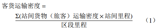
客货运输密度指在一定时期内某种运输方式在营运线路的某一区段平均每公里线路通过的货物(旅客)运输周转量,分别按上、下行计算,计算公式为
客货运输密度=Σ(站间货物(旅客)运输密度×站间里程)区段里程 (1) 3.1.3 基于客座利用率的监测计算方法
客座利用率指铁路客车平均载运人数与每辆客车平均定员人数的比值。它表明铁路客座利用是否充分、超员是否严重,其计算公式为
客座利用率=客车载客人数客车平均定员人数×100% (2) 3.2 基于GIS的铁路网能力可视化表达
3.2.1 “线路−区段−站间”数据分级表达
本文基于铁路地理信息平台提供的铁路线路、车站、分界站GIS数据,按照每季度铁路调整的运行图情况,对铁路GIS数据按类型、比例尺维度进行分类分级划分。
(1)按照“线路−区段−站间”进行动态划分
利用GIS动态分段技术,对高速铁路网、普速铁路网空间数据进行自动拆分。对划分后的铁路GIS区间数据定义唯一的编码,并计算其区间里程信息,实现与铁路实际运行图、客货密度、客座利用率的自动匹配。
(2)按比例尺进行可视化划分表达
在宏观比例尺(L1~L6)下,对线路的通过能力、客货密度、客座能力利用率进行统一表达,并设定不同的阈值,对不同的线路采用不同的颜色进行动态渲染,反映线路的整体繁忙程度和拥堵情况;在中观比例尺(L6~L10)下,对区段的通过能力、客货密度、客座能力利用率进行统一表达,中观地图下依据调度区段进行划分,关联区段的里程长度、合资公司、开行对数、开行车次、限制坡度等指标信息;在微观比例尺(L10~L20)下,以站间及站场枢纽为划分依据,重点关联站场货物的到发量、站间运输能力等数据信息,实现微观数据的集中可视化表达。
3.2.2 基于GIS的多源数据参数指标关联
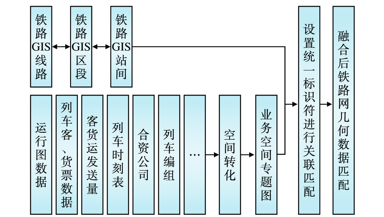
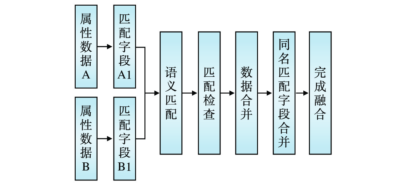
铁路网能力利用分析系统融合了铁路运输、调度、经营等多个专业的数据信息,主要包含计算后的列车开行对数、客票数据、货票数据、客运发送量、货运发送量、合资公司信息、列车时刻表、列车编组、WTDS等数据指标内容,其与GIS数据的融合主要包括几何特征匹配和属性信息匹配这2部分,如图2和图3所示。
几何特征匹配主要是铁路GIS数据与业务数据的空间特征整合,通过设置统一标识符,将不同层级的几何数据(线路、区段、站间)与业务数据(运行图、客货票、时刻表、列车编组等)进行关联。匹配流程为:从铁路GIS数据中提取几何层级信息(如线路的起点、终点、区段划分等),同时从业务数据中获取与空间相关的指标(车站发送量、线路开行对数等);利用唯一标识符(线路编码、车站电报码等)将两者进行映射匹配,确保地理空间位置与业务逻辑的一致性。
属性信息匹配旨在融合铁路GIS数据与业务数据的属性字段,消除冗余并构建统一的数据结构。匹配流程为:识别不同数据源中的匹配字段,通过语义分析确定字段间的逻辑关联性;进行匹配检查,验证字段值的兼容性;通过合并同名字段或创建映射规则,将多源属性整合至同一要素中;生成融合后的属性表,既能保留原始数据的核心信息,又避免重复字段,提升数据利用效率和分析准确性。
4 系统应用情况
铁路网能力利用分析系统已在国铁集团及部分铁路局集团公司上线试用。该系统能够直观、可视化地表达高速铁路和普速铁路在宏观、中观、微观层面的铁路网能力,确保用户能准确、完整地掌握铁路运输信息,有效提高了对铁路网能力的统计、分析及决策应用的效果,实现了对铁路运输能力堵点问题的快速识别和原因判定,进一步提高了分析效率。
5 结束语
本文设计了铁路网能力利用分析系统,为国铁集团及各铁路局集团公司提供了高效、准确的铁路网运输信息,试应用期间取得了良好的应用效果,积累了大量的数据经验,为铁路规划建设、精准投资决策及应用决策奠定了良好基础。下一步,将在该系统中逐步接入更多铁路运输数据指标,开展枢纽运输能力的分析研究,从而逐步支撑更多面向铁路运输能力的分析决策工作。
-
表 1 普速铁路网实际能力利用率指标说明
参数指标 指标说明 各区间追踪运行时分 将货物列车之间追踪运行时间与运行图进行比较,验证运行图参数的合理性,并依据不同列车间追踪运行时分,确定追踪换算系数。 各区间运行时分 比较不同列车区间占用时间,用于计算各等级车次换算系数。 各区间起停附加时分 开行较高速度等级列车,对普通货物列车的影响次数,及起停附加时分,计算不同等级列车对能力的附加影响系数。 施工天窗及前后准备时间 从实际运行线验证,天窗时间需协调调度命令确定,若研究确定各区段有固定天窗时间,后续可计算天窗内开行列车数量及能力情况。  下载: 导出CSV
-
[1] 吴金龙,丁小兵,刘志钢,等. 快慢车模式下基于扣除系数的线路通过能力研究[J]. 城市轨道交通研究,2021,24(3):97-101. [2] 权诗琦,游艳雯. 提升铁路线路通过能力对策探讨[J]. 铁道货运,2019,37(12):6-11. [3] 中华人民共和国铁道部. 铁路区间通过能力计算办法:铁运字[1984]664号[S]. 北京:中华人民共和国铁道部,1984. [4] 褚文君. 双线铁路通过能力图解计算方法研究[J]. 铁道运输与经济,2020,42(1):12-18,30. [5] 秦宝来,耿敬春,赵 昕,等. 一种重载铁路通过能力计算方法:中国,CN111090929A[P]. 2020-05-01. [6] 周 黎,张 超,胡思继. 线路运输能力计算方法及其在京广线能力计算中的应用[J]. 北京交通大学学报,2006,30(6):32-35. [7] 于进江,刘文斌,刘国梁,等. 基于倾斜摄影技术的铁路三维实景系统开发与应用[J]. 中国铁路,2021(1):111-116. [8] 甘秋云,陈 鑫,姚 伟. 铁路客运站列车运行图资料自动编制方法与应用[J]. 铁道运输与经济,2024,46(1):26-34. [9] 黄 睿,钱 琳,王凤琳,等. 基于列车运行线的铁路货车运行里程计算方法[J]. 铁路计算机应用,2023,32(3):6-10.

计量
- 文章访问数: 39
- HTML全文浏览量: 18
- PDF下载量: 17
